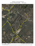
Middle Line Woods Preserve
Size
54.3 acres
Description
This property’s location, next to the Chilmark landfill, makes it an inauspicious location for a memorable natural experience, right? Wrong. The ridgelines are high — with snatches of views of the Buzzards Bay, beyond Pasque Island — and the boulders here rival Waskosim’s Rock, Devil’s Bed and other island notables.
Access
Begin at the intersection of the North and Tabor House Roads. Travel 0.4 miles on the Tabor House Road and turn left onto the Middle Line Road; trailhead is 0.1 miles ahead.
Historical Highlights
- the preserve is named for the “Middle Line” stonewall that historically separated land owned by the Wampanoag natives, to the north, and the land of the Thomas Mayhew family to the south
- the old footpath bisecting the preserve connects to the Holman Road ancient way, which was used to transport raw clay to the north shore brickworks

